• CLICK HERE To Join Broke Straight Boys & Instantly Get Full Access To Entire Site & 3 FREE bonus sites.

Weather

Here we go again with Ida.

So who in here do we have who's living in or close to the coast anywhere in the central Gulf of Mexico? From southeastern Texas, encompassing all of the Louisiana Gulf coast, all of the Mississippi coast, and even the westernmost part of the Florida panhandle?

Unless the forecasters totally screw this up...this one could be really bad. If they start forecasting a landfall of a category 3 you have to take it very seriously. Not just because a Cat 3 hurricane is capable of damaging some buildings and tossing around mobile homes...but because a predicted Cat 3 hurricane can overachieve expectations, rapidly intensify, and come in as a Cat 5. And of course a Cat 5 is no joke. It means guaranteed loss of life, major flooding, major collapse of buildings, homes, trailer parks, huge storm surge, etc.

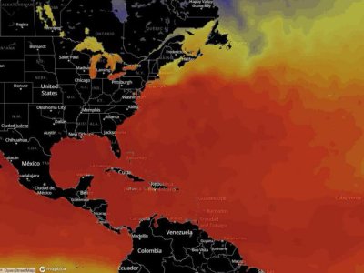
They started out predicting Ida's landfall as a Category 3. Now they've already bumped it up to a predicted probable Cat 4 at landfall. Which means they (the people living there) should be preparing for a worst case scenario of a Cat 5, and hope they're spared a true Cat 5. The other thing they have going against them is that the waters of the central Gulf are very warm right now. (Which is the fuel for tropical systems.) The other bad news is that the waters off the Louisiana coastline in particular are some of the warmest waters in the whole Gulf of Mexico right now. So rather than it being a scenario where you catch a break, have cooler waters off the coast and the hurricane weakens at least a little bit just before landfall...we could have the opposite situation where's it's still strengthening (perhaps rapidly) until the last moments before final landfall.

We could get lucky if the timing of landfall coincides with an eyewall regeneration cycle, where the storm naturally weakens briefly and shores up a new eyewall for itself. But that's technical stuff. Regardless though, this one will be a nail biter if the current forecast holds to be even three fourths true.

I belong to a Mardi Gras krewe in New Orleans which had a general meeting scheduled for next Monday. To illustrate how seriously New Orleans is taking this hurricane, they cancelled that meeting yesterday!
 
I belong to a Mardi Gras krewe in New Orleans which had a general meeting scheduled for next Monday. To illustrate how seriously New Orleans is taking this hurricane, they cancelled that meeting yesterday!

Yes. This is likely to be a really big deal. I realize in my geography list of the areas in danger from Ida that I forgot to mention all of the coastline of Alabama.
 
Here's a map showing the SST's (Sea Surface Temperatures) of the North Atlantic and North and South America. The pinks, reds and dark reds represent the warm water. Darkest reds being the warmest.

Map of SST.jpg


Note the thin ribbon of darker red Gulf water running from the eastern Texas coast through pretty much all of the Louisiana coastline.

Source: https://www.wunderground.com/hurricane?index_region=at
 
Yikes! That is some really warm water!

Everyone please stay safe!! Thoughts and prayers to everyone in the path
 
Sadly people fail to take into account when settling and building the probability of natural areas. No body should be allowed to live along low lieing areas and yes these conditions are ripe for a very bad storm, so tragic so sad. I hope people take heed and flee these areas.
 
Katrina was a monster storm of course. And even though it reached Cat 5 strength in the center of the Gulf of Mexico, it went through an eyewall regeneration cycle, weakened, and made landfall as "only" a Cat 3 hurricane. And it still killed so many and destroyed so much. The height of storm surge that it pushed ashore however was considered to still be nearly equivalent to a Cat 5 storm.
 
Katrina was a monster storm of course. And even though it reached Cat 5 strength in the center of the Gulf of Mexico, it went through an eyewall regeneration cycle, weakened, and made landfall as "only" a Cat 3 hurricane. And it still killed so many and destroyed so much. The height of storm surge that it pushed ashore however was considered to still be nearly equivalent to a Cat 5 storm.

Which emphasizes my point I made above. It may be nice to live along the shore but it is not wise. That holds all the way up the East coast. The West Coast is a different story due to different terrain.
 
Sadly people fail to take into account when settling and building the probability of natural areas. No body should be allowed to live along low lieing areas and yes these conditions are ripe for a very bad storm, so tragic so sad. I hope people take heed and flee these areas.

A mandatory evacuation order was issued for anyone living outside of the levee protection, which supports your point. Post Karina the Army COE spent a lot of money improving and strengthening the levees. This could be the first big test.
 
So far we are getting lucky and not seeing the rapid intensification they were predicting earlier. Ida only has 17 more hours over open warm water to strengthen. For now they're pulling back on the prediction of a CAT 4 landfall and making it a CAT 3. But tomorrow is another day. And time will tell.

I repeat though that Katrina was "only" a Category 3 hurricane at landfall. So even if Ida is not a CAT 4 or 5, doesn't mean that it will be a walk in the park. There could still be great loss of life, extreme flooding rains, great storm surge heights piling up sea water on the shoreline leaving much infrastructure along the coast sitting on the bottom of the ocean for several hours. Along with structural wind and water damage to many other homes and buildings also. The other sucky part about the forecast is that once it makes landfall it's expected to slow way down. So it will soak and soak the same areas with heavy rain for hours on end.

It may not be as bad as the way Hurricane Harvey did to Texas in 2017. Harvey came ashore and then pretty much stalled out and parked itself just inland. And then it sat there for literally days raining over the exact same spots. They are not predicting quite that bad for Ida. But they are saying that flooding rains inland along the coast will probably be worse than normal due to the slowing down of the storm.

Here's some trivia about Harvy that I found interesting and helped refresh my memory. From Wiki:

*******************************************************

Late August 2017 – Hurricane Harvey makes landfall on San José Island near Rockport as a Category 4 hurricane on August 26 with sustained winds of 130 mph (215 km/h).[153] The Aransas County Airport in Rockport registers a peak wind gust of 145 mph (233 km/h) within Harvey's eyewall. Extensive wind damage occurs in Rockport and Fulton, with many roofs blown off and walls torn apart; widespread damage also befalls nearby communities.[154] Storm surge inundates areas along San Antonio and Hynes bays under as much as 8–10 ft (2.4–3.0 m) of water, resulting in major flood conditions.[153][154]

Weak steering currents cause Harvey to slowly meander along the Texas Coastal Plain for several days, subjecting large swaths of the region to prolonged and torrential rainfall from the storm's rainbands.[153][155] The rains constitute the most prolific rainfall event associated with a tropical cyclone in U.S. history, with the peak rainfall total of 60.58 in (1,539 mm) near Nederland setting the national record for the largest rainfall total measured in connection to a tropical cyclone;[153] at least 18 observing sites report amounts exceeding the previous record for the contiguous U.S. of 48 in (1,200 mm).[156] The unprecedented scale of the rainfall in both extent and magnitude causes catastrophic flooding, displacing approximately 1.8 million people.[153][155] Bayous in the Greater Houston area rapidly rise and overrun their banks, prompting evacuations and submerging parts of Houston; 60,049 residents are rescued.[155] Parts of all 22 major freeways in the metropolitan area suffer inundation.[157] Tens of thousands of homes in Southeast Texas are inundated by record flooding.[158]

In total, Harvey's effects destroy 16,930 homes and damage 290,063 homes.[155] At least 68 deaths are directly attributed to Harvey's forces, making it the deadliest hurricane in Texas since 1919; an additional 35 deaths are indirectly attributed to Harvey. The NOAA estimates a $125 billion damage toll for Harvey, making it the second costliest hurricane in U.S. history when adjusting for inflation and the costliest hurricane in Texas history.[153][159]


********************************************************************

Source: https://en.wikipedia.org/wiki/List_of_Texas_hurricanes_(1980–present)#2010–present
 
Last edited:
Well it appears that some meteorological news sources are still sticking by a prediction of a Category 4 landfall. So we'll see what we're looking at tomorrow afternoon.
 
TY for update, frnklyI don't listen to much news I use to be an avid news listenernbut since Trump I stopped.
 
Wow! The rapid intensification did happen overnight and Ida jumped from a Category 2 to a CAT 4. They're saying its last recorded max winds (as of now) are at 150 mph. And it still has a few more hours over very warm water to possibly strengthen further. 150 mph is a high end CAT 4 storm. It only has to strengthen by 7 mph to reach CAT 5 status.

Here's a guide to the scale they use:

Tropical Depression < 39 mph
Tropical Storm 39-73 mph

CAT 1 74-95 mph

CAT 2 96-110 mph

CAT 3 111-129 mph

CAT 4 130-156 mph

CAT 5 157+ mph
 
Tampa as you no the Gulf is a reservoir of warm waters & warm water is a source of great energy for topical systems and they can & do explode. Also the opposite is true especially going up the East coast where the warm Gulf stream abides a cold current traveling south. The record highest speeds are over 200 mph in the Pacific a much larger body of water & the Indian Gulf an open gulf which is even warmer.
 
It appears that the post Katrina improved levees in New Orleans have held. Caveat though, with Katrina it was not until the day after that one component of the system broke and flooded almost all of the city. Ida's winds were so strong that at one point today the Mississippi River stopped flowing south and started flowing north!
 
Let us hope thheycontinue to hold. We have the capacity to marvelous things and sadlyit is equally true to do horrific things as well.
 
It appears that the post Katrina improved levees in New Orleans have held. Caveat though, with Katrina it was not until the day after that one component of the system broke and flooded almost all of the city. Ida's winds were so strong that at one point today the Mississippi River stopped flowing south and started flowing north!
Yeah. That's great news that the new levee system appears to have held.
 
We are at thr hright of the hurricane season with 2 more storms in the Atlantic
 
South Florida Sun Sentinel
Tropical Storm Kate forms; forecasters monitoring 2 other systems besides Ida
Robin Webb, South Florida Sun-Sentinel
Mon, August 30, 2021, 6:32 AM·2 min read
Tropical Storm Kate formed Monday in the central Atlantic Ocean from Tropical Depression Ten, though it’s expected to stay east of the U.S. mainland.

Kate, the 11th named storm of the 2021 season, was moving north at 8 mph with maximum sustained winds of 45 mph as of 2 p.m., according to the National Hurricane Center.

Kate formed on the heels of what turned out to be a short-lived Tropical Storm Julian. Julian formed Sunday morning over the central Atlantic Ocean, but it was downgraded to a post-tropical cyclone about 24 hours later.
 
Last edited:
The remnants of Ida are heading to the Northeast today and New York City is going to get very wet and low lying areas will be flooded. But once again I live in Brooklyn Heights, 85 feet above sea level, so I feel pretty safe and secure, but it will be a wild 24 hours in the surrounding areas.

NEW YORK (WCBS 880) – A Flash Flood Watch is in effect for the entire New York City area as the remnants of Ida threaten the Tri-State with torrential rain, severe thunderstorms and the potential for isolated tornadoes on Wednesday and Thursday.

What-Could-Change.png


SkyCast-FutureCast-Wind-Gusts-EURO.png


ida-impacts-a9957129-b889-4319-853d-3c7b491bfa49.png


Stay safe, all in the path of Ida!
 
Top